


Finding the Fountain Inn, again
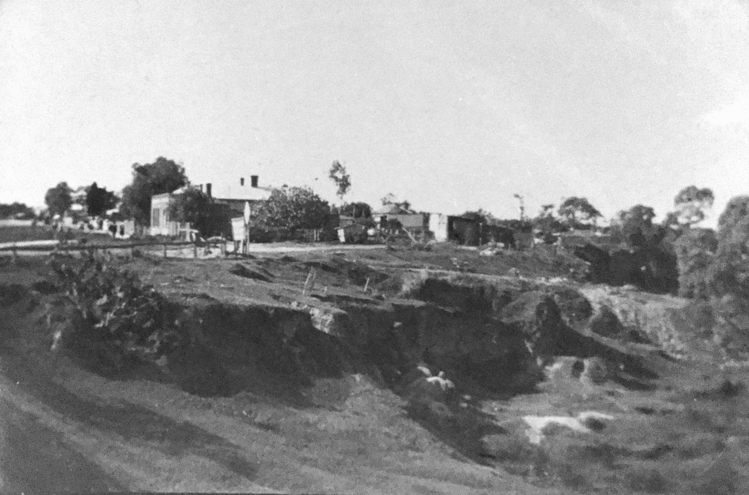
Brenton Seager, whose great-grandparents lived next door to the Fountain Inn, has referred me to Samuel Sweet's "View of Lower North Adelaide...", a photograph taken in about 1872 and clearly showing the Fountain Inn in mid-distance (see below). Very small, but unmistakably the old pub. Thank you and well spotted, Brenton.
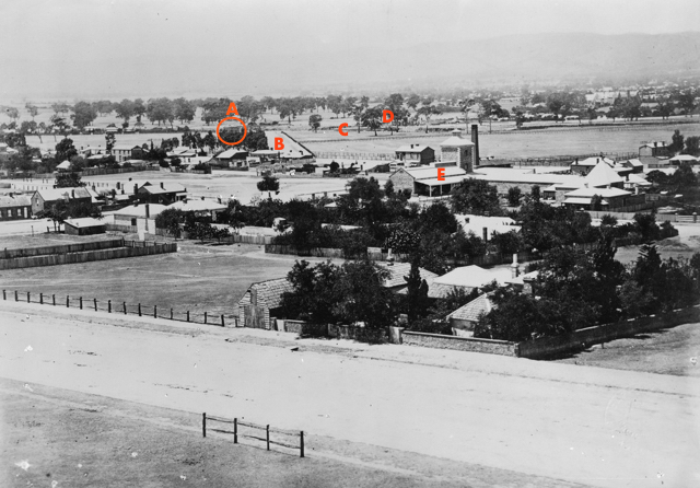
Above: "View of Lower North Adelaide looking from Stanley Street towards the Adelaide foothills"
Below: Detail, showing the Fountain Inn
[State Library of South Australia, B 6418] A: the Fountain Inn; B: Bundeys Road; C: the second Company Bridge; D: the Company's Steam Mill, demolished in the mid-1870s; E: the Lion Brewery, built in 1871.
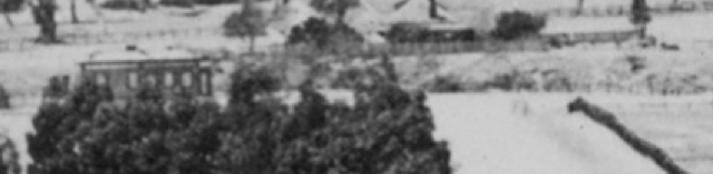
This photograph implies that the location of the Fountain Inn was about 20-25 metres north of the junction of Bundeys Road with what is now Park Terrace – about 50 metres further north than I'd calculated! This would have placed the old pub at about 59-61 Park Terrace, Gilberton.
However, several contemporary plans [a] suggest that, from its construction in mid-1871 and until the construction of the eastern part of War Memorial Drive in 1920-24, Bundeys Road intersected with what became Park Terrace further south than its current position. Ironically, as shown below, a more southerly alignment seems to confirm that The Fountain Inn was located within the range that I proposed originally.
Revised location of the Fountain Inn
[Base map from LocationSA; A: Smith's 'Sketchbook' plan of Bundeys Road, 1881, Adelaide City Council Archives, Adelaide City Survey, Book 11, p.56; B: Detail of photograph above, rotated and scaled]
Notes
a For examples: State Records of South Australia: Surveyor General's Office, Plan of the City of Adelaide, showing parklands and reserves, 1879, GRG35/585/00000/3 Item 22; and National Library of Australia: [Vaughan's] City of Adelaide and park lands, 1895
Finding the Fountain Inn, Gilberton, 1851 - 1862
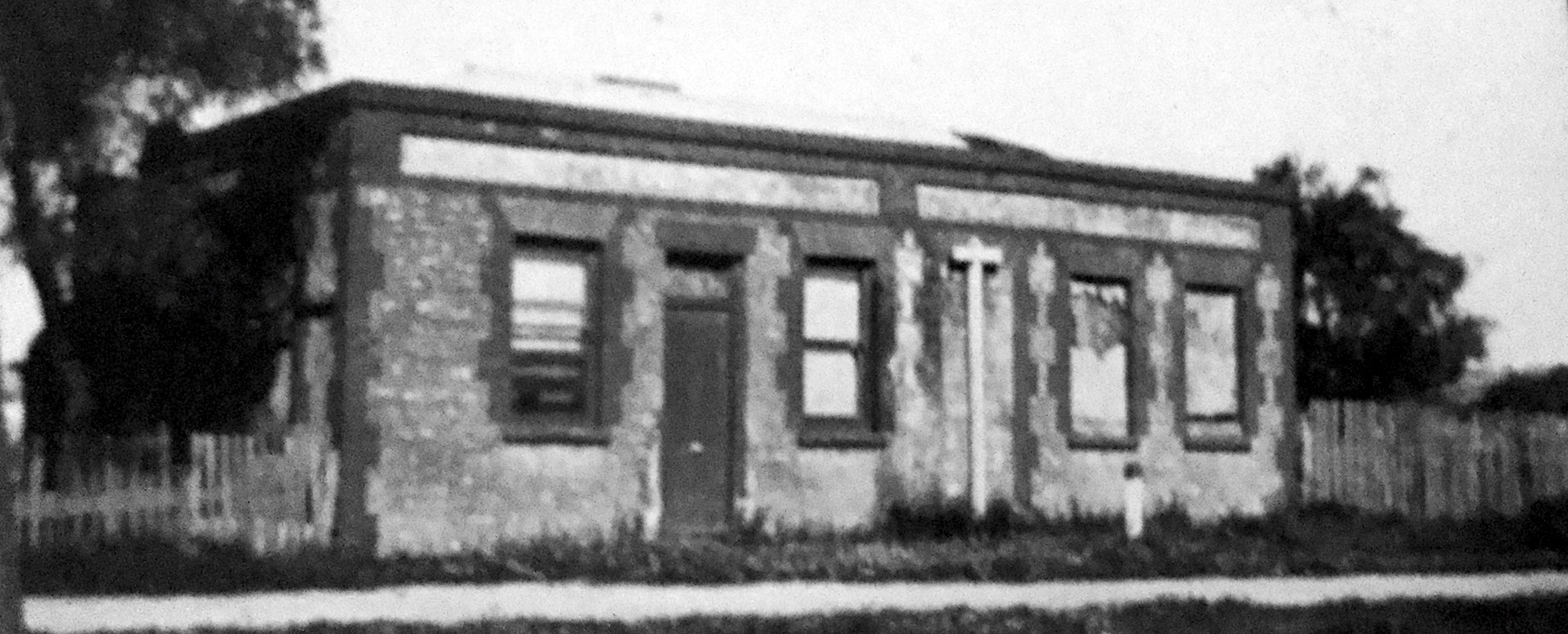
In about 1910, J G Otto Tepper photographed the building that, from 1851 to about 1862, was the Fountain Inn public house on what is now Park Terrace in Gilberton [1]. Part of a sequence of photographs that Tepper took near the Hackney Bridge and the River Torrens, these seem to be the only known images of the Fountain Inn. Despite the poor quality of the original prints and my copies, these are reproduced below.
 Click to enlarge in new window | 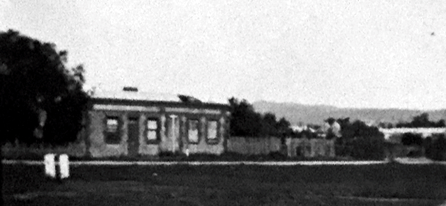
Click to enlarge in new window |
[All photographs: State Library of South Australia, Tepper Papers PRG 313]
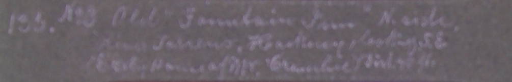
Although there is no name or other signage visible on the building, digital enhancement of the hand-written caption below the photograph immediately above clearly identifies it, and therefore the sequence, as the "Old 'Fountain Inn'":
| 135
No.3 | Old
"Fountain Inn" N[orth] side |
Click to enlarge in new window
Despite the Fountain Inn having been long since demolished, we've been able to locate fairly accurately where it once stood.
From March to November 1854, Joseph Gilbert, who then owned the land on which the Fountain Inn was built, and Joseph Crombie, who was then the lessee and licensee of the Fountain Inn, waged a protacted dispute in the Supreme Court over 'ownership' of an island in the River Torrens. The Court determined that Crombie "occupied an acre of land, part of Preliminary Section 475 [Gilberton], on which the Fountain Inn was situated, and of which he was landlord," and "being the Allotment numbered 43" on Enrolment Plan 78 of 1852 [2]. Registered on 24 December 1852, Enrolment Plan 78 was effectively Gilbert's subdivision of "Gilbert Town" and set out the position and dimensions of the allotments; the plan shows allotment 43 on the northern bank of the River Torrens at the southern extremity of Gilbert Town [3]. The Court also confirmed the dimensions of the parcel of land: 310 feet (94.5m) by 284 (not 286) feet (86.6m), enclosing an area of approximately one acre. It did not, however, establish the exact location of the Fountain Inn.
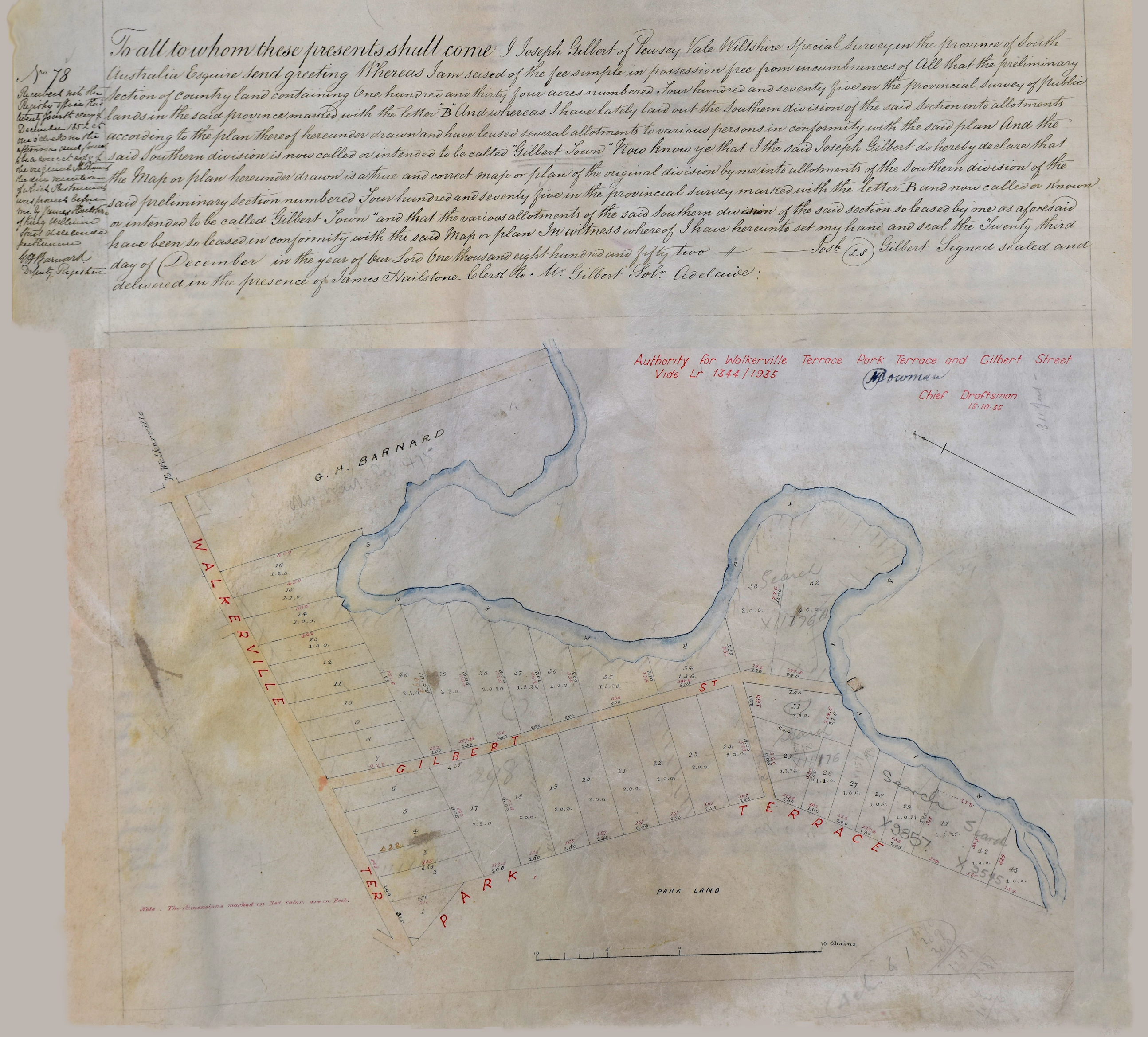 |
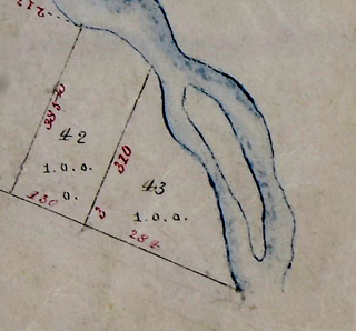 Enrolment Plan 78 of 1852 [State Records SA, GRS/12147/00001/13] Left: Digitally enhanced facimile of the complete document. Click to enlarge in new window (large file, approx 5MB) Above: Detail of the Plan showing location of allotment 43, including the contentious island. |
|
From 1880 the South Austraian Department of Engineering and Water Supply progressively
surveyed metropolitan Adelaide in preparation for the installation of deep sewerage and recorded the position and
dimensions of every permanent structure in 'sketchbooks' more or less for each suburb.
The sketchbook for Gilberton [4], initially surveyed in 1881, shows clearly what can only have
been the Fountain Inn and, hence, the building photographed by Tepper thirty years later.
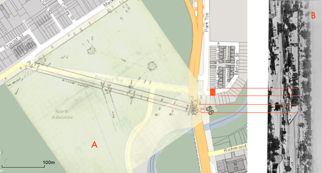
By overlaying, at the same scale, this 'sketch' (with the Fountain Inn and the two major boundaries of 'Lot 43' highlighted), Robert Frearson's Plan of Walkerville... (c1910) (showing 'Lot 43', the banks of the Torrens and the 'Company Bridge') [5] and a recent satellite image of the area [6], we can locate more presicely where the Fountain Inn would have stood. Using this method, the most likely site of the Fountain Inn is 39 Mersey Street, at the southern end of Park Terrace in Gilberton, marked 'A' on the image below. |
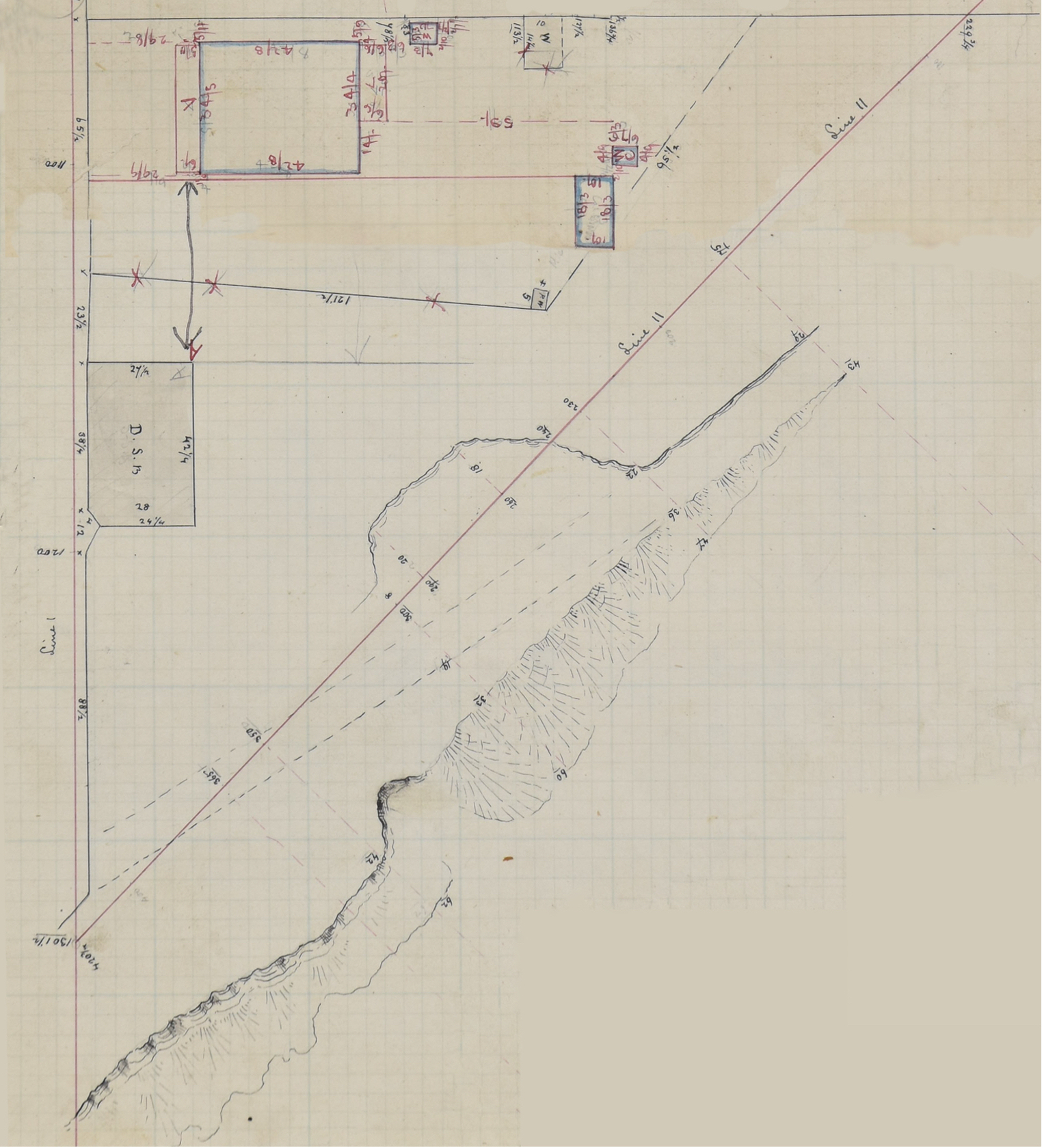
Sketch Book of properties in Gilberton, showing the Fountain Inn, 1880-1881. [State Records SA,GRS 53/166/00001/3 Book 9] Click to enlarge in new window (large file, approx 5MB) |
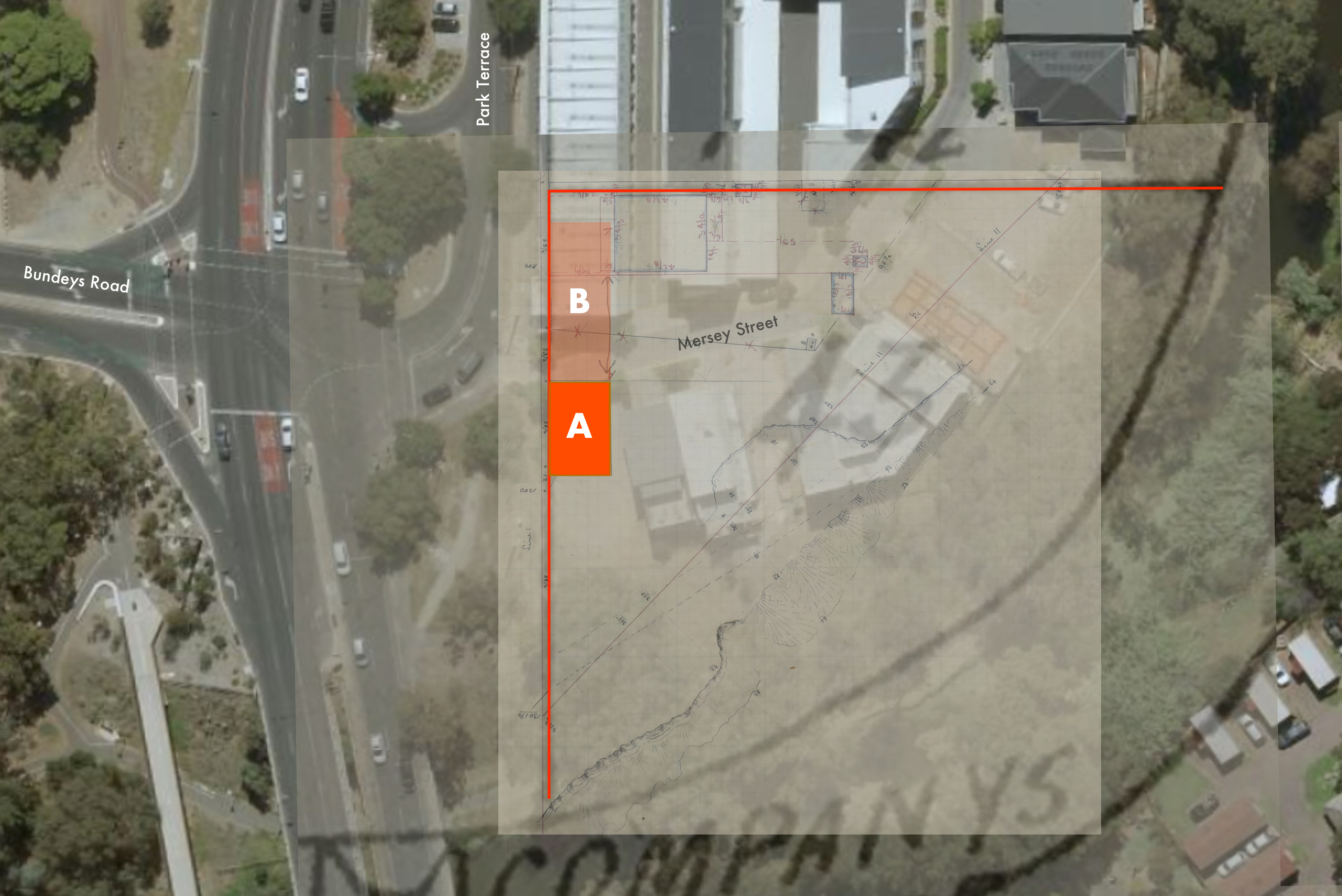
Location of the Fountain Inn, Gilberton
This location is also consistent with the dimensions of 'Lot 43' (310' [94.5m] x 284' [86.6m]) specified initially in the Enrolment Plan of 1852 and with the measurements recorded in the 'sketchbook'. However, mostly because the banks of the Torrens were not well defined and the course of the River itself changed substantially over time, the accuracy of this method cannot be guaranteed. What's more, an analysis of the large Tepper photograph reproduced above suggests that the Fountain Inn was located further north along Park Terrace, somewhere in the area marked 'B'.
Not that the exact the location of the Fountain Inn really matters now. However, when the pub was being built in early 1851, its location certainly did matter. Sited prominently on one of the few major routes to the north and north-east of Adelaide, adjacent to then the most reliable crossing over the River Torrens, immediately across the river from the South Australia Company's (Stephen's) Steam Flour Mill and connected to North Adelaide by the track that would eventually become Bundeys Road, the Fountain Inn was more auspiciously situated than its closest competitors, the British (1837), the Sussex Arms (1843), the Kentish Arms (1848), the Buckingham Arms (1849) and the Lord Melbourne Inn (also 1851) Yet, these pubs flourished and survived while the Fountain Inn ceased trading as a public house in or soon after 1862.
Notes
1 State Library of South Australia, Tepper Papers, PRG313
2 South Australian Register, 7 November 1857
3 State Records SA, GRS 12147/00001/13, Enrolment Book 13, 11 August 1851 - 14 January 1853; also Land Titles Office, Enrolment Book 78/13
4 State Records SA, GRG 53/166/00000/1 Book 9 1881-1884
5 State Library of South Australia, "Robt. S. Frearson's plan of Walkerville [cartographic material] : showing Walkerville, North Walkerville, Medindie and Gilberton...", after 1908, C40 F3 c5-F4 c2
6 Government of South Australia, Location SA MapViewer, Satellite Image, accessed 13 September 2020
Posted: 10 August 2020. Original content © Craig Hill 2020.
Updated 16 September 2010 and 14 November 2020
With many thanks to Lyn O'Grady, Honorary Local Historian for the Town of Walkerville, and Brenton Seager.